| AltRefNo | Rocque map - 1746 |
| Title | [The Horse Ferry between Millbank and Lambeth on John Rocque's map of 1746] |
| Description | John Rocque was an 18th century cartographer. This section of his map of London shows the horse ferry which operated between Millbank and Lambeth before Westminster Bridge was built in 1751. The ferry was a flat bottomed boat which was large enough to carry a coach and 6 horses. |
| Date | 1746 |
| Thumbnail | 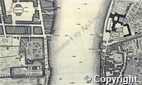
|
| Access Status | Open |
Show related Persons records.
Persons
| Code | PersonName | Dates |
| NA231 | Rocque; John (c1709-1762); surveyor and cartographer | c1709-1762 |
Places
| Code | Set |
| PL655 | Millbank/St Margaret, Westminster |
| PL925 | Horse Ferry/St George, Hanover Square |
| PL928 | St John, Smith Square (Church)/St margaret, Westminster |
| PL533 | Thames (River)/St Margaret, Westminster |